Ph.D. Research Proposal - Petra Kranzfelder
Check out my research and travel blog.
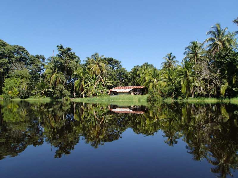
Figure 1. Estero Negro, Costa Rica.
Background: Estuaries are among the most productive environments in the world and many of these estuaries occur in Central America.10Thousands of species of birds, fish, amphibians, and other wildlife depend on estuaries to live, nest, and reproduce.13 Costa Rica hosts at least 5% of the world’s biodiversity in an area that is approximately the size of the states of Vermont and New Hampshire combined. Considering this, biodiversity conservation of these estuaries is essential to the Costa Rican economy, which earns around $2 billion per year from the ecotourism industry.4 Consequently, estuaries are ecologically and economically indispensable in Costa Rica. Human activity is altering estuaries on the Caribbean coast of Costa Rica. Terrestrial sediments and contaminants transported from deforested banana and pineapple plantations and urbanized lands impact the health of these estuaries.3 Interdisciplinary research methods that evaluate watershed land use changes and aquatic biodiversity can be linked to monitor anthropogenic impacts on the water quality of Costa Rican estuaries (Fig. 1).
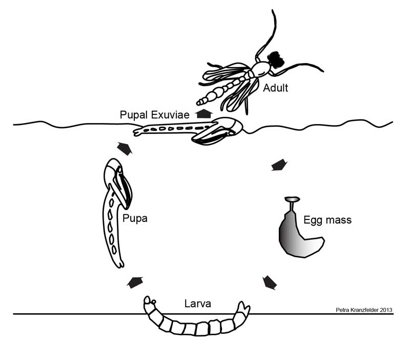
Figure 2. Life cycle of Chironomidae (non-biting midge).
One group of animals abundant in estuaries is a family of aquatic flies, commonly known as the non-biting midges (Fig. 2). Aquatic insects, such as midges, are commonly used in biological monitoring of water quality, since these organisms are sedentary in nature, have relatively long life cycles, and low dispersal capacity.6 Midges are found worldwide and frequently the most abundant insect family in aquatic systems.1 Spies & Reiss (1996) predict that hundreds of species and many genera without names still exist in regions like Costa Rica. Only 1/5th of the estimated 1,000 species of midges in Central America have been recorded.12 Importantly, in my Master’s research, I discovered over 44 genera and 110 species of midges without names in one estuary, Laguna del Tortuguero, Costa Rica.9
Remotely sensed satellite images can be used to create land use and land cover (LULC) maps. LULC maps are classified in categories (e.g. forest, agriculture, urbanization, pasture), and can be used to understand how land use changes affect estuaries. Frequently, these data are used to generate landscape-based metrics and monitor status and trends over a specified time interval.8
Rationale: Midge community composition can be used to monitor ecosystem health of Costa Rican estuaries.9 Some species inhabit water of high quality, while others only dwell in water of low quality, so community composition of these midges can be used to predict pristine and impaired waters.5 The Costa Rican national park system, three biological research stations, and several non-profit conservation organizations have expressed interest in evaluating the water quality of estuaries on Caribbean coast of Costa Rica. While there has been some work on midge community composition in estuaries, the cumulative effects of urbanization and agriculture on the midge community in estuaries, in countries like Costa Rica, have not been studied and therefore is not well understood. This will be the first study to conduct concurrent biological and geospatial monitoring of estuaries on the Caribbean coast of any country in Central America.
Objectives: The goal of my dissertation research is to understand the cumulative effects of urbanization and agriculture on aquatic biodiversity in Neotropical estuaries of Costa Rica. My main objectives for this research are to: (1) collect and analyze midge diversity, (2) create and interpret watershed land use/land cover maps from remotely sensed satellite images, and (3) examine linkages between watershed land use/land cover changes and midge diversity to monitor water quality of estuaries.
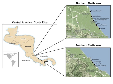
Figure 3. Costa Rica sample area.
Experimental Design: I chose nine estuaries within different watersheds located along the Caribbean coast of Costa Rica (Fig. 3). Land cover in these nine watersheds range from mostly being covered with primary tropical rainforest to largely covered with banana plantations. To fulfill my first objective,I will collect midge samples, measure water chemistry, and qualify habitat parameters from these estuaries. Collections are scheduled biannually for two consecutive years (July 2012, Jan. 2013, July 2013, Jan. 2014). Each of the nine estuaries will be sample one-day during each sample event. Mean total monthly precipitation along the Caribbean coast of Costa Rica is 424.1 mm in July and 319.7 mm in January.8Therefore, two July sample events were selected to represent the wet season and two January sample events were selected to represent the dry season. In order to get a complete representation of aquatic health from each estuary, I will collect data from three areas that represent a range of aquatic ecosystems: (1) the transition of the river and its estuary, (2) the middle of the estuary, and (3) near the outlet of the estuary to the ocean.
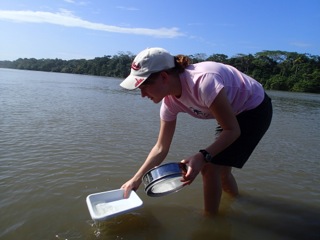
Figure 4. Collecting Chironomidae pupal exuviae.
One efficient form of sampling midges involves collection of the pupal skins or exuviae (Fig. 4).12 Collections of midge pupal exuviae follow methods described by Ferrington et al. (1991). Midge pupal exuviae samples will be collected along 500-meter reaches of the left and right banks at each sample area. Samples are collected from both banks to account for hourly to daily changes in wind and tidal pattern, which may affect the down water drift of midge pupal exuviae. Over the course of this project, 216 samples will be collected, processed, and used for data analysis (9 estuaries x 6 samples/estuary x 4 sample events). I will bring midge samples from Costa Rica to the University of Minnesota, where I will process and identify specimens to species using primary literature (Fig. 5).
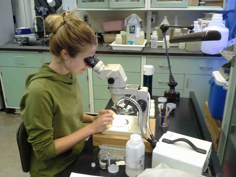
Figure 5. Picking and sorting Chironomidae samples in lab.
Midge adults will be collected for species description and as a supplement to the ecological pupal exuviae data. I plan on applying for a 2014-15 Fulbright fellowship to describe new species with DNA sequencing techniques at the Norwegian University of Science and Technology. Adults will be collected on a regular basis near the estuaries. Standard light trap collections methods will be used to collect adults.2 The light trap will be set up at dusk and adults will be collected by hand from the light trap for several hours and then placed into vials with 95% ethanol. Genetic and morphological methods will be used to identify unknown species.
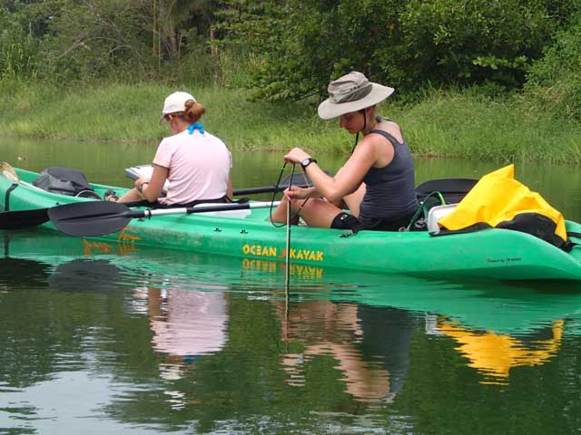
Figure 6. Collecting physiochemical data from estuary.
Water chemistry measurements will be taken at the deepest point of all three-sample areas in each estuary and will include the following readings: water temperature, dissolved oxygen, conductivity, salinity, total dissolved solids, and clarity. The YSI Pro2030 field dissolved oxygen/conductivity handheld meter will be used. The meter will be vertically stratified in the water column and measure water chemistry every 1-meter until the bottom of the estuary. These readings will allow me to create a hydrographic profile of depth versus water chemistry reading at 1-meter intervals. To measure water clarity, a secchi disk is lowered into the water and the depth at which it vanishes from sight will be used to quantify water clarity (Fig. 6).13
Estuary habitat parameters will be qualified at all three-sample areas in each estuary. To assess the habitat, standardized qualitative measurements on physiochemical, geological, biological, etc. conditions, such as water velocity and aquatic vegetation, of the estuary and surrounding terrestrial areas. Then, I will use appropriate statistical methods to analyze relationship between midge diversity, water quality, and estuarine habitat.
To complete my second and third objectives, I will work with faculty member, Dr. Joe Knight, from the Remote Sensing and Geospatial Analysis Lab. We plan to use imagery analysis methods to create and interpret watershed land use/land cover maps. More specifically, we plan to use state of the art techniques based on Object-Based Image Analysis (OBIA) and the Random Forest classification algorithm to identify the LULC classes of interest in the study area and track changes over time.
Broader Significance: I think that the combination of using measurements of midge diversity, water chemistry, and estuary habitat, and land use/land cover maps will allow me to successfully conclude the cumulative effects of urbanization and agriculture on estuaries. My dissertation research will determine connections between estuary health data and watershed land cover/land use data to make conservation and management recommendations for Costa Rican estuaries. This cross-disciplinary research will make a significant global contribution by developing an estuary-monitoring model in Costa Rica that will be beneficial for policy-making at both the regional and international scale.
References cited (.pdf)